
A new study gets us closer to an answer
Thanks to a recent hydrogeological study, Nosara has maps and other vital information on the water available. What we know so far is troubling but not irreversible.
The study gathered and evaluated information already available about water supply in Nosara and indicated what kind of information is still needed to produce an accurate picture of our area’s water resources. The study was commissioned by NCA and funded by a donation from the Harmony Hotel.
A hydrogeological study is a prerequisite for a zoning plan as part of a federally required Municipal Regulatory Plan, which will include zoning for Nosara. The study has been submitted to SENARA (the National Groundwater, Irrigation and Drainage Service). With SENARA’s approval, the next phase can begin.
On November 27 Laura Chavarria and Jorge Suarez from Hidrogeotecnia, Ltd., presented the findings and conclusions of the first phase of their work to local ASADAs and representatives of local groups.
Among the findings:
- The region studied — Nosara town, Santa Marta, Santa Teresita, Pelada, Guiones, and Esperanza — has 166 registered wells, of depths ranging from 8 to 212 meters, with an average depth of 43.5 meters; according to SENARA, the number of unregistered wells may boost these figures up to 50% higher.
- A total of 11 registered wells lies within 1 km of the coastline from Garza to Rio Montaña. Extraction from these wells, augmented by extraction from unregistered wells (both drilled and hand-dug), is contributing to salt water intrusion. We already know this intrusion is increasing above permitted limits, especially in Guiones below Route 160.
- The difference in water depths from one well to another suggests the presence of a wide variety of aquifers and geological structures.
- According to law, every hand-dug well must be protected from any kind of alteration to the soil by at least a 40-meter radius. Otherwise, it is very likely that your wastewater, and your neighbor’s, is entering your well.
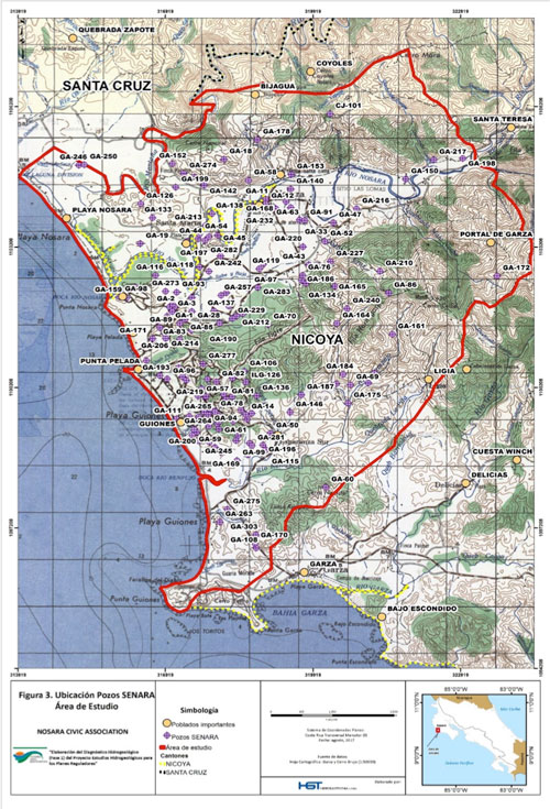 Location of registered wells in the area studied
As part of Phase 2 the authors will develop and analyze several diagnostic maps and will delimit and map areas at high risk of contamination in greater detail. These actions will allow them to suggest measures to lower the risk.
Phase 2 will perform tests to answer the questions raised by the diagnosis. Specifically, the scientists will investigate salt water intrusion, contamination, groundwater availability, and the capacity of the aquifers, springs, and wells in the Nosara District to replenish themselves.
A third phase will propose land use regulations.